

John Deere precision agriculture product manager Benji Blevin says that establishing good boundaries is vital for precision farming
In an emerging autonomous landscape, the post and wire fences that used to define a farm’s boundaries are being replaced by digital ‘geofences’, and it is critical to ensure that these important pieces of precision agriculture infrastructure are accurately measured.
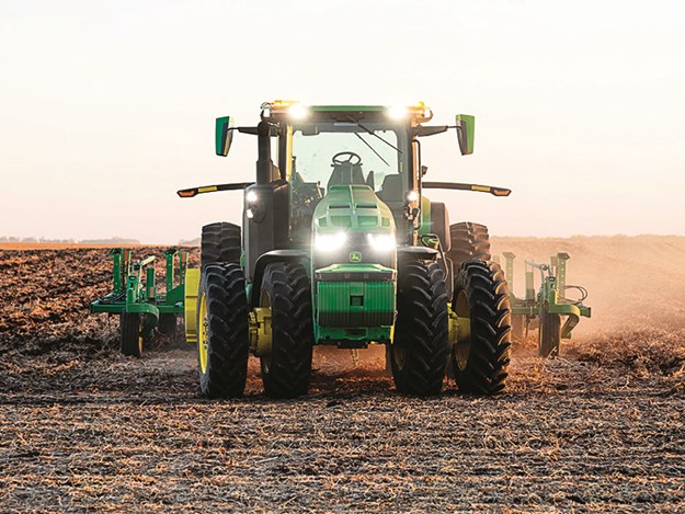
John Deere demonstrated its first fully autonomous 8R tractor in the US in January, and boundaries are the critical digital infrastructure required to guide it. Paired with guidance lines, these virtual geofences enable the machine to plot its path through an entire field.
Australian farmers are already using much of the technology on the autonomous 8R – AutoTrac Turn Automation, Boundary Track Guidance and Section Control – and this all requires accurate boundaries to function.
In short, the word ‘boundaries’ refers to a digital map of each of the fields that make up a farm. In addition to automating machine functions, boundaries enable farm data to be accurately captured, stored, and automatically transferred to farm management platforms such as the John Deere Operations Center.
 |
|
The fully autonomous John Deere 8R was demonstrated in the US in January
|
The question is, are the boundaries you have in place good enough today and will they guide an autonomous tractor in the future?
In my experience, the first thing a grower wants to do with a new tractor is put it to work in the field. Boundaries are usually only considered after data has been collected and farmers have to make sense of it. But data that isn’t associated with a boundary has little or no value. And it’s becoming increasingly clear that without accurate boundaries, we cannot have fully autonomous farming equipment.
Finding the right method to measure
There are various ways of measuring digital boundaries, each with their own level of accuracy that needs to be considered when you are looking to implement any form of machine automation. The simplest but least precise way to create boundaries for a farm operation is by drawing them on a map on a computer. Alternatively, an agronomist or another third party may already have boundaries electronically mapped, and it is just a matter of uploading these into Operations Center.
But these methods are only sufficient for data collection, management and analysis, and are not recommended when using machine functions such as turn automation or section control.
Investing the time to establish long-term, repeatable boundaries is the best way to prepare your operation and reap the rewards from the remarkable advancements in data and automation that are already emerging.
The most accurate method of creating digital boundaries requires the farmer to physically drive along the edge of their field with a GPS receiver on board that has a Real-Time Kinematic (RTK) correction signal enabled. RTK ensures long-term repeatable accuracy within 2.5 centimetres. John Deere displays have built-in functionality to guide you through the process of driving and recording boundaries, or you can contact your local dealer, who may offer RTK boundary mapping as a service.
Boundaries can also be created by using previously recorded coverage. A seeding operation is generally the most accurate source for creating a boundary as most farmers generally seed all the available hectares. If RTK accuracy was used during seeding, this method of boundary creation can then be used for data collection and management as well as machine automation.
Build profitability, map opportunity
Accurate digital field boundaries are the foundation on which increased business efficiency and profitability can be built, by enabling farmers to make better decisions. Not many of us have the time to sit down and analyse all the available map layers for each field individually, but a farm management platform like the Operations Center can highlight where the greatest opportunities may exist.
Boundaries can be thought of as a digital folder that automatically stores all relevant data in one place, making it easier to understand trends and derive insights. For example, by looking at historical yield data and pairing this with other available data such as soil types, growers can better understand the variabilities that are affecting crop growth. Management decisions become clearer, leading to improved outcomes such as reduced inputs or increased crop yield or quality.
Boundaries also represent an opportunity for growers to differentiate their business. We have a supply chain and consumers who are seeking produce from sustainable sources. It is a simple process to automatically record every operation or pass that occurs on every field, unlocking the ability to easily demonstrate sustainable farm practices and environmental stewardship without the need for manual record keeping.
In the same way as a good set of fences kept livestock contained and protect crops, properly defined digital boundaries are pivotal to capturing the benefits of autonomous farming.